
Map shows coldest places in US as polar vortex descends
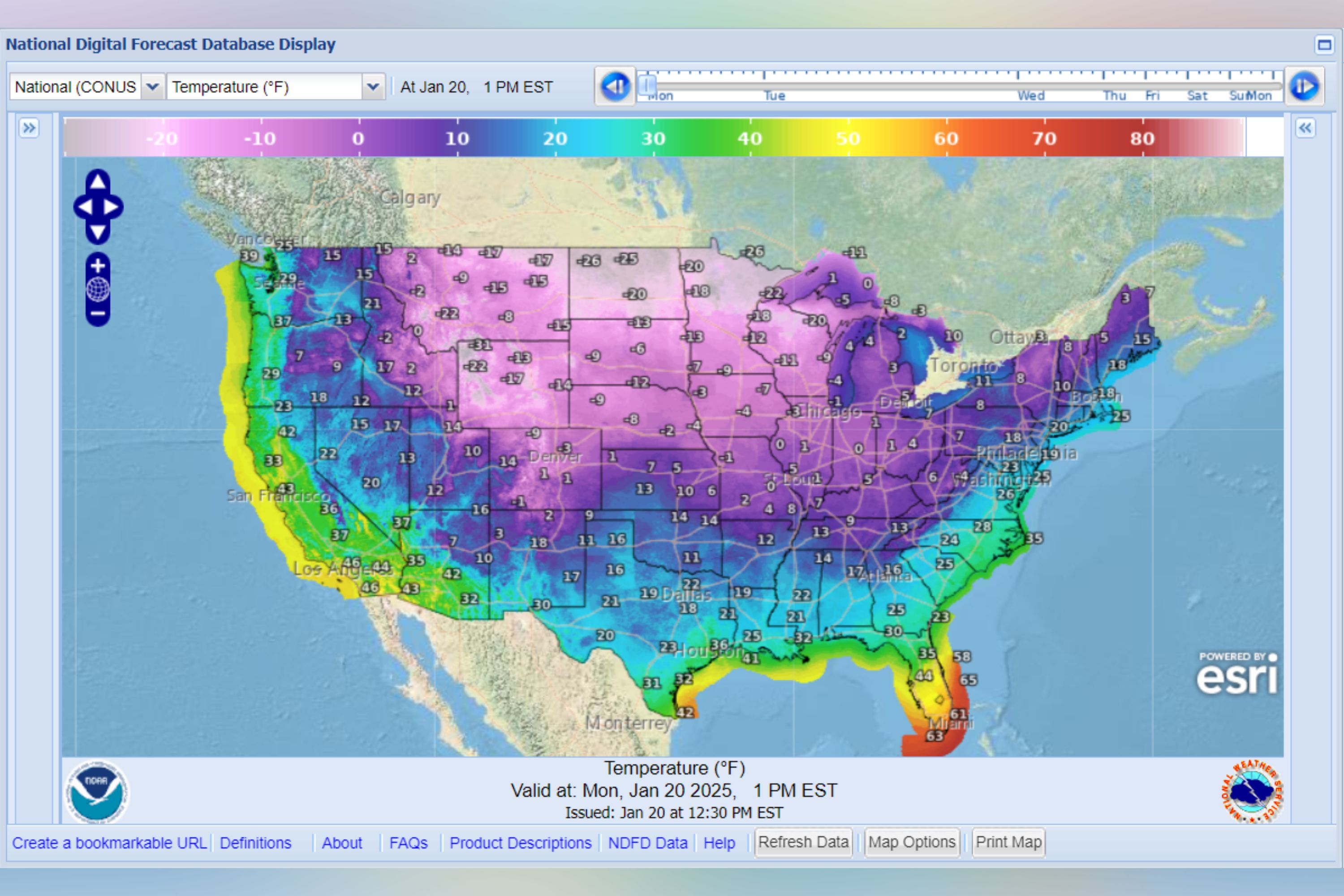
Much of the U.S. could see bitterly cold temperatures on Monday, after Arctic air was forecast by the National Weather Service (NWS) to spread south and east from the Rockies this week.
Why It Matters
Much of the U.S. has been facing challenging winter weather. Snow can disrupt travel and lead to hazardous driving conditions. Winter storms can also trigger power outages.
Additionally, freezing temperatures may present health risks, especially for vulnerable groups like infants and senior citizens
What To Know
A forecast from the NWS showed that in the contiguous U.S., at 1 p.m. ET, Monday, the vast majority of the country would be experiencing below-freezing temperatures.

Northern Minnesota would see temperatures around -26, as could North Dakota.
Temperatures around -22 in Montana were possible, as was -31 in Northwest Wyoming.
In Indiana, around zero degrees was likely, the map showed, with temperatures of around three degrees possible in Northern Maine.
Northern Georgia would see temperatures around 16, and in Colorado, the map showed that some areas would see -9.
Even as far south as Texas, frigid temperatures could occur on Monday, with the map showing around 16 degrees in parts of the Panhandle.
Winter Storm Enzo is forecast to bring subfreezing temperatures, snow, and ice to the Gulf Coast states early this week.
According to the NWS, the Arctic polar vortex is a powerful band of west-to-east winds that develops in the stratosphere, about 10 to 30 miles above the North Pole, during the winter season.
It is always present near the poles, though it weakens during summer and intensifies in winter.
During winter in the Northern Hemisphere, the polar vortex often expands, pushing cold air southward along with the jet stream.
What People Are Saying
NWS Weather Prediction Center said in a post on its website: "A bitterly cold arctic airmass has overspread the interior western, central, and eastern U.S. following a strong cold front passage over the weekend.
"Forecast high temperatures Monday from the Great Basin/Rockies east to the East Coast will be upwards of 20-30 degrees below January averages, ranging from the negative teens and single digits in the northern Plains/Upper Midwest; the single digits and teens in the Rockies, central Plains, and Midwest; the teens and 20s for New England and the Mid-Atlantic; and the 20s and 30s for the Great Basin, southern Plains, and Southeast."
What Happens Next
The NWS had earlier forecasted that hazardous cold weather would likely persist along the Gulf Coast and across the Southeast U.S. for much of the week.
Do you have a story we should be covering? Do you have any questions about this article? Contact LiveNews@newsweek.com